You searched for: all images in the database. Here are the results:
- Refine Search
- Thumbnails
- List
- Image Details
- Distribution


Title:
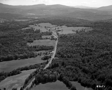
Interstate Planning Aerial
|
|
|
- Date:
- 1964-08-27
- Description:
- This image is an aerial used for interstate planning before construction in Thetford Center. There is a road running diagonally through the frame, and it is mostly surrounded by fields. Where there aren't fields, it is forest full of coniferous and leafy deciduous trees. In the distance, there are wooded mountains.
- Filename:
- LS43173_000.jpg
- Size:
- 3889 x 3104 pixels; 5858584 bytes
- Original Filename:
- AOTN09351.jpg
- Original Metadata:
- Aerials = Thetford Ctr, Island Pond, Derby, Clyde Pond, St. Albans. Interstate Planning. Before Construction. Thetford Center.
- Keywords:
- Trees; Roads; Nature; Mountains; Living Things; Landforms; Human Constructs; Geology; Forests and Plants; Deciduous; Culture; Conifers;
- Source:
- Vermont State Archives and Records Administration
- Photographer:
- Donald Wiedenmayer
- Submitted By:
- Sara Krumminga
- Submitted On:
- 2011-12-20
- Original Media:
- FIlm Negative
- Image Scanned By:
- Josh Ellsworth
- Catalogue Information:
- Negative #9351
- Relative Dating Rationale:
- Original Metadata
- Times viewed:
- 191


