Map Research
A number of historic maps were drawn up for Vermont's towns and cities in the 19th century. One map can be a helpful research tool, but map comparisons can provide much more information about your historic image. Ask your local library or historical society about maps that are available in your town. A few common maps are listed below:
Many bird's eye maps were drawn during the second half of the 19th century and are available on this site.
Walling's Maps were produced for a large number of Vermont towns in 1857.
Beer's Atlas Maps were produced for a large number of Vermont towns in 1869.
Sanborn Fire Insurance Maps were produced for a number of locations during the 19th and 20th centuries.
Several Burlington maps are available online:
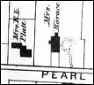
a have more than one map available for any town or city, a comparison of those maps can provide excellent information for narrowing the date of your historic image. Bird's eye maps have small hand-drawn images of buildings, and many details, such as roof styles, porches, windows, number of stories, are accurately depicted (although not all details are always 100% accurate). Most other maps have what are called footprints, which is a small, usually black, one-dimensional outline of the shape of a building. A detailed building from a bird's eye map is seen on the left, and a building footprint is seen on the right.

It can sometimes be difficult to determine if the building you see in your image matches a footprint, because buildings often receive additions over time. However, if the building appears to have roughly the same shape, size, and location on the lot, it may indeed be the same building. Once you have found an historic map on which the building in your image appears, examine earlier maps (if they are available) to find out when the building first makes an appearance. See example below:
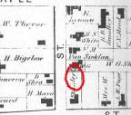
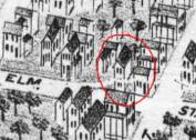
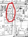
The building in the above example appeared on the 1877 Bird's Eye Map (center) but not the 1869 Beer's Atlas Map (left). Therefore, we know the building was constructed between 1869 and 1877. This information alone says your image is not older than 1869. But now you can use other buildings - or empty lots - in the image to narrow the date. Notice the empty lot in the bottom left hand corner of the 1877 map (center). That lot is developed on the 1890 map (right). If your image contains the building circled on the 1877 map and the empty lot, you can infer that the image dates between 1869 and 1890.
Map research can be helpful with individual buildings, however, this type of research is most effective for images with several buildings or streetscapes.


