Lesson Plans from Local Teachers
These are "in-class" lessons developed in 2006 and 2007 by Vermont K-12 teachers in curriculum development workshops at the University of Vermont.
| Science | Language Arts | Social Science | |||||||||||||||||||||||||||||||||||||||||||||||||||||||||||||||||||||||||||||||||||||||||||||||||||||||||||||||||||||||||||||||||||||||||||||||||||||||||||||||||||
| "Geo-Snapshots" Geology Grades 4-5 by Claire Draper (pdf) (doc) |
Before and After Stories Storyboards Grades 4 + by Alison Novak (pdf) (doc) |
Photo Detectives Town History Grades 1-2 by Janet Bellavance (pdf) (doc) |
|||||||||||||||||||||||||||||||||||||||||||||||||||||||||||||||||||||||||||||||||||||||||||||||||||||||||||||||||||||||||||||||||||||||||||||||||||||||||||||||||||
| Reading Rivers Over Time Geology Grades 3-6 by Matt Dubel (pdf) (doc) |
Our Changing Community Conducting Research Grades K-4 by Pat O'Brien (pdf) (doc) |
There's More Than One Way to View a Photo Photo Interpretation Grades 3-4 by Marybeth Morrissey (pdf) (doc) |
|||||||||||||||||||||||||||||||||||||||||||||||||||||||||||||||||||||||||||||||||||||||||||||||||||||||||||||||||||||||||||||||||||||||||||||||||||||||||||||||||||
| Identifying Landforms Physical Geography & Technology Grades 3-4 by Tim Bourne (pdf) (doc) |
"Sense" of Place Sensory Language Grades 6-8 by Sandra Fary (pdf) (doc) |
What's the DAM Project People's Impact Grades 6-8 by Tim Bourne (pdf) (doc) |
|||||||||||||||||||||||||||||||||||||||||||||||||||||||||||||||||||||||||||||||||||||||||||||||||||||||||||||||||||||||||||||||||||||||||||||||||||||||||||||||||||
| Then and Now...and in the Future Resources and Sustainability Grades 7-8 by Gabriel Hamilton (pdf) (doc) |
I See Dead People (and So Much More) Digital Stories (mov) Grades 5-8 by Debra McConnell (pdf) (doc) |
Transportation and Change in Williston Local History Grades 5-8 by Richard Allen (pdf) (doc) |
|||||||||||||||||||||||||||||||||||||||||||||||||||||||||||||||||||||||||||||||||||||||||||||||||||||||||||||||||||||||||||||||||||||||||||||||||||||||||||||||||||
| Dams, Logging, Erosion...Oh My!! Watersheds Grades 9-12 by Brian Slopey (pending) |
School Daze Gazette: Schools Then and Now Newspaper Grades 9-12 by Shelley Snyder (pdf) (doc) |
Time Travel Local History & Lifestyles Grades 6-12 by David Schoales (pdf) (doc) |
|||||||||||||||||||||||||||||||||||||||||||||||||||||||||||||||||||||||||||||||||||||||||||||||||||||||||||||||||||||||||||||||||||||||||||||||||||||||||||||||||||
| Finding the Forest through the Trees Forest Succession Grades 10-12, Alternative Education by Helen MacAndrews (pdf) (doc) |
Where Am I? Anthology of Place Grades 9-12 by Becky Ebel (pdf) (doc) |
What Have We Here? Artifacts Grades 9-12 by George Olson (pdf) (doc) |
|||||||||||||||||||||||||||||||||||||||||||||||||||||||||||||||||||||||||||||||||||||||||||||||||||||||||||||||||||||||||||||||||||||||||||||||||||||||||||||||||||
| Rocks, Redox, and Remediation Mining in Vermont Grades 9-12 by Abby Hood (pdf) (doc) |
|
"It Takes an Image of a Village:" History Guiding the Future
Vermont Sustainability Grades 7-12 by Scott Evan Beckwith (pdf) (doc) |
|||||||||||||||||||||||||||||||||||||||||||||||||||||||||||||||||||||||||||||||||||||||||||||||||||||||||||||||||||||||||||||||||||||||||||||||||||||||||||||||||||
| Resource name and description | Download Size |
|---|---|
| Unit Plan: How has this town's landscape changed over time? (Includes 8 lessons, final Assignment, and introduction). | 308 kb |
Unit Lesson Plans
These are the individual lesson plans from the unit above
| Resource name and description | Download Size |
|---|---|
| Lesson #1 Introduction to Landscape Change Unit | 53 kb |
| Lesson #2 How can we use technology to infer landscape history? | 47 kb |
| Lesson #3 How has Vermont's glacial history affected where cows live? (Vermont's Geologic History) | 56 kb |
| Lesson #4 How has Vermont's physical environment affected its cultural history? (VT's Settlement History) | 49 kb |
| Lesson #5 How has Vermont's cultural history affected its physical environment? | 45 kb |
| Lesson #6 How do we interpret historic images and aerial photos? | 51 kb |
| Lesson #7 Field Walk: What evidence of landscape change can we find in our nearby forests? | 47 kb |
| Lesson #8 CULMINATING ACTIVITY. How has this town's landscape changed over time? | 46 kb |
Lesson Materials
These are resources for each of the individual lesson plans from the unit above
| Introductory Materials for students | File type | Size | |
|---|---|---|---|
| Small | Large | ||
| Final Assignment Handout (This is a handout detailing step by step the process of taking historic/current photo pairs) | Word(.doc) | 53 kb | |
| Latitude and Longitude Help sheet | Word(.doc) | 31 kb | |
| Location Form (A form for students to fill out while gathering photos to ensure that they've gathered all the correct metadata) | 3.8 kb | ||
| Lesson #1: Introduction to Landscape Change Unit | File type | Size | |
|---|---|---|---|
| Small | Large | ||
| Introductory Slideshow (Introduces the Landscape Change Project) | PowerpointWebsite (.html) | ||
| Introductory Slideshow (Introduces the Landscape Change Project) | Powerpoint(.ppt) | 13,065 kb | |
| Lesson #2: How can we use technology to infer landscape history? | File type | Size | |
|---|---|---|---|
| Small | Large | ||
| Worksheet: Practice using GPS, Digital Camera, and data transfer software | Word(doc) | ||
| Lesson #3 How has Vermont's glacial history affected where cows live? (Vermont's Geologic History) | File type | Size | |
|---|---|---|---|
| Small | Large | ||
| Map of Glacial Lakes (8.5* 11) | 64 kb | ||
| Diagram of cross sections of major movements in Tectonic Plates | 98 kb | ||
| PowerpointSlideshow of Vermont's History of Plate Tectonic Movement | Powerpoint(.ppt) | 2,950 kb | |
| View Plate Tectonics Slideshow | Website (.html) | ||
| Lesson #4 How has Vermont's physical environment affected its cultural history? (VT's Settlement History) | File type | Size | |
|---|---|---|---|
| Small | Large | ||
| Photo set of periods in VT Settlement History | Powerpoint(.ppt) | ||
| Lesson #5How has Vermont's cultural history affected its physical environment? | File type | Size | |
|---|---|---|---|
| Small | Large | ||
| Photo set of impacts associated with VT Settlement History | Powerpoint(.ppt) | ||
| Diagram showing time periods of different Native American weapon points | Powerpoint(.ppt) | 28 kb | |
| Powerpointslideshow showing the History of Vermont's Forests | Powerpoint(.ppt) | 23,306 kb | |
| View History of the Vermont Forest Slideshow | |||
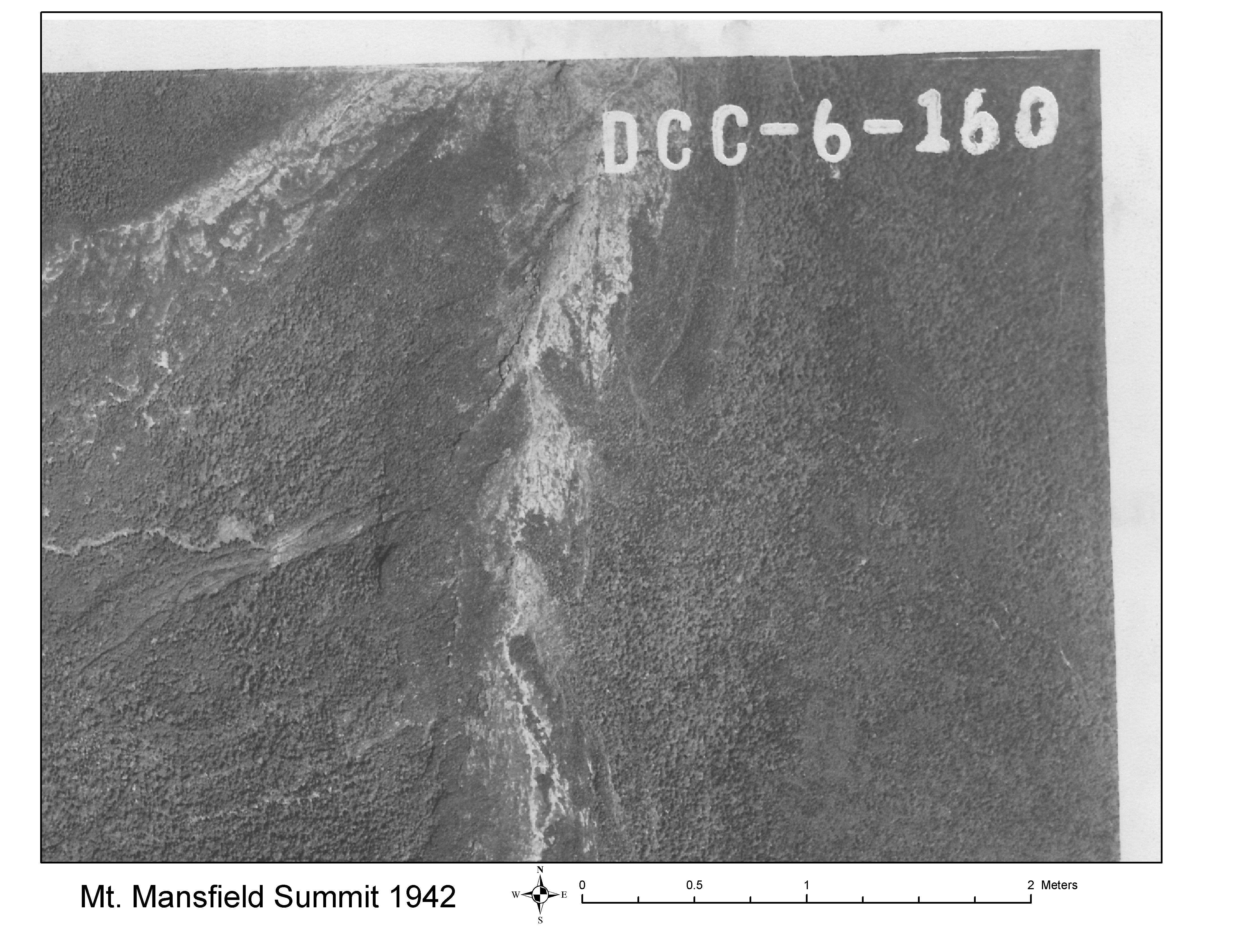
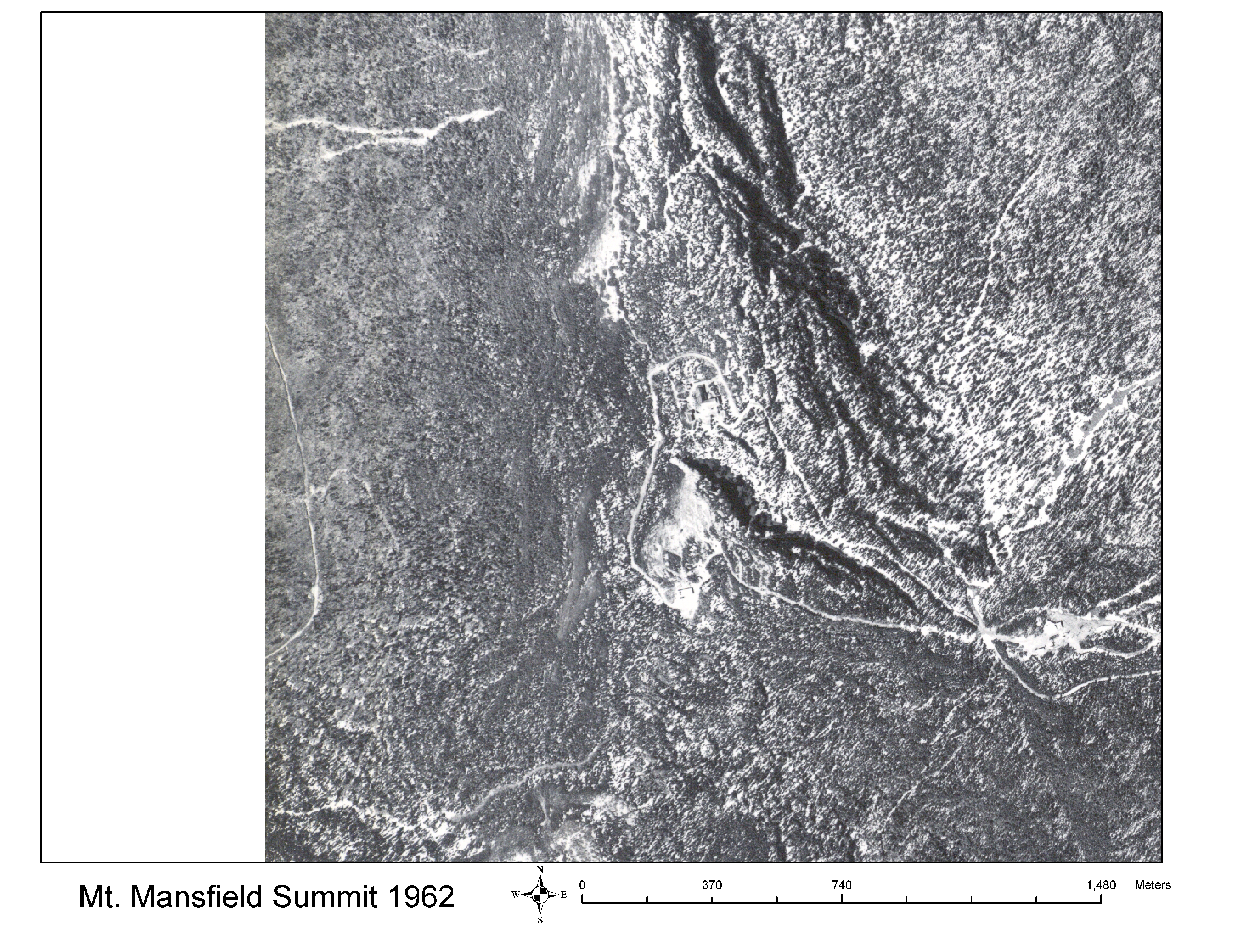
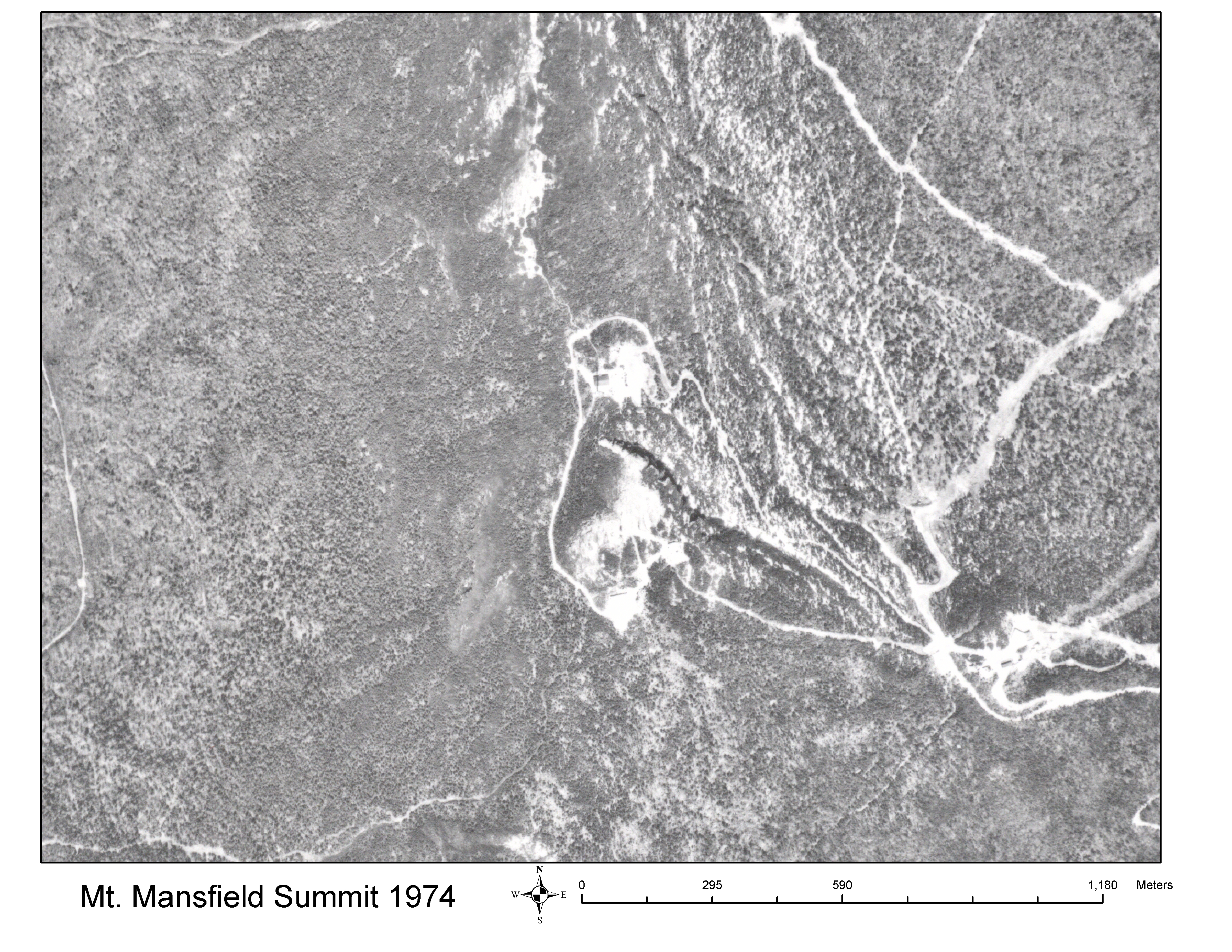
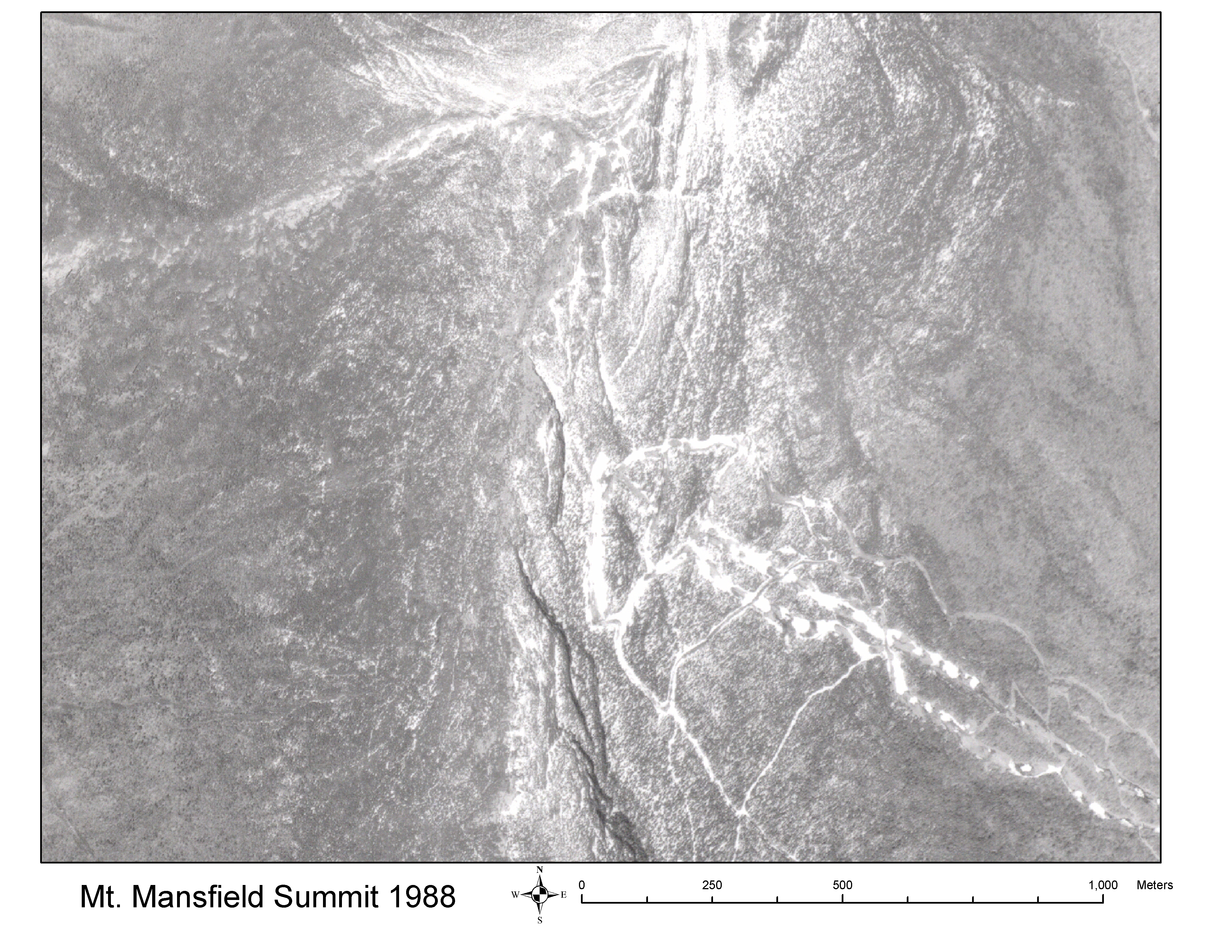
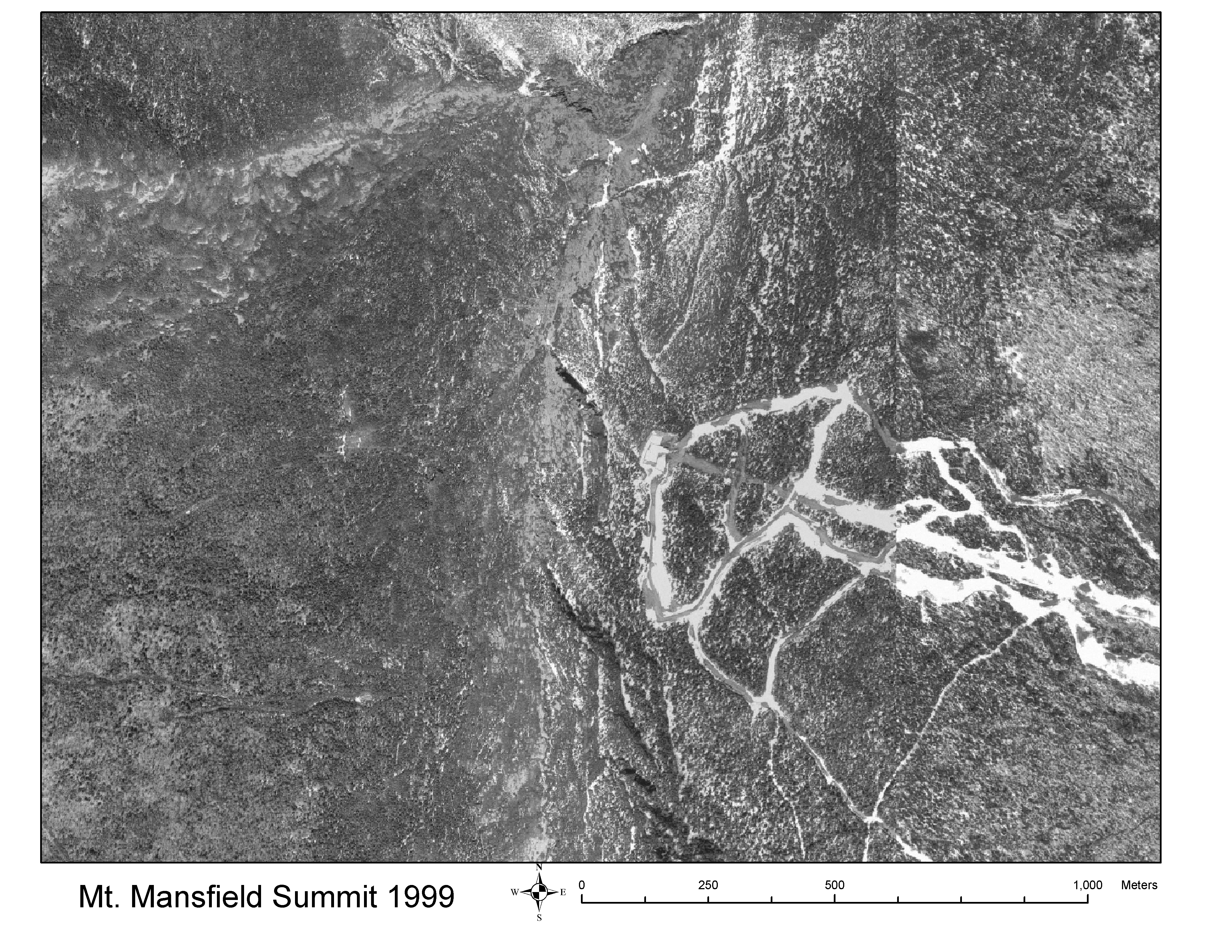
| Lesson #6 How do we interpret historic images and aerial photos? (This set of Aerial Photos of Mt. Mansfield Summit shows the reforestation and ski area development that has occurred since 1942.) | File type | Size | |
|---|---|---|---|
| Small | Large | ||
| Mt. Mansfield Summit Aerial Photo 1942 | Image (jpg) | 6,354 kb | |
| Mt. Mansfield Summit Aerial Photo 1962 | Image (jpg) | 10,799 kb | |
| Mt. Mansfield Summit Aerial Photo 1974 | Image (jpg) | 11,046 kb | |
| Mt. Mansfield Summit Aerial Photo 1988 | Image (jpg) | 10,207 kb | |
| Mt. Mansfield Summit Aerial Photo 1999 | Image (jpg) | 10,072 kb | |
| Mt. Mansfield Physical Geography Slideshow (Maps of Soils, Bedrock, Topography, Land Use, and Drainages) | Powerpoint(.ppt) | 30,071 kb | |
| Go to Terraserver on out links page to see and print aerial photos of anywhere in the U.S. | |||
| Lesson #7 Field Walk: What evidence of landscape change can we find in our nearby forests? | File type | Size | |
|---|---|---|---|
| Small | Large | ||
| Stonewalls and Cellarholes excerpts | 4,018 kb | ||


